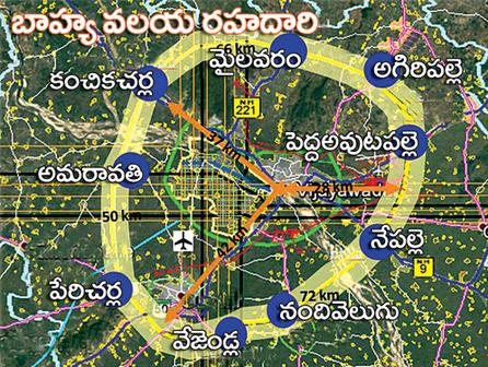
 Amaravati, the new capital city of Andhra Pradesh state will have a Outer Ring Road (ORR) with a length of 186 km. The Government of Andhra Pradesh has decided to go with the proposed plan to set up ORR around Amaravati. The Government has also released ORR Map for the reference.
The villages that goes through ORR in Amaravati are kanchikacharla, Amaravati, Lingapuram, Patibandla, Mandapadu, Perecharla, Pulladigunta, Ananthavarappadu, Vezendla, Nandivelugu, Vallabhapuram, Vallurupalem, Nepalle, Vetthipadu, Peda Avutapalli, Chopparametla, Narsingapalem, Agiripalli, Sobhanapuram, Koduru, Mylavaram, Gangineni.
Following are some more features of proposed ORR in Amaravati:
1) Length of ORR: 186 km
2) Width of ORR: 120 – 150 meters
3) 8 lane and 2 lane service roads
4) Bridges on Krishna River: East Bridge – 4.5 km, West Bridge – 3.5 km
5) Areas inside ORR: 5,40,838 acres (Except river and forest area)
6) Present population inside ORR: 35 lakhs
Satellite townships around ORR will be Jaggaiahpet, Nandigama, Sattenapalli, Piduguralla, Narasaraopet, Chilakaluripet, Bapatla, Ponnur, Challapalli, Machilipatnam, Pamarru, Vuyyur, Gudivada, Hanuman Junction, Eluru, Nuzvid, A Konduru.
Growth Centers around ORR: Kanchikacharla, Amaravati (Old), Perecharla, Vejendla, Nandivelugu, Nepalle, Pada Avutapalli, Agiripalli, Mylavaram.
Urban Nods around ORR: Guntupalli, Pedaparimi, Peda kakani, Peda Vadlapudi, Gannavaram, Nunna.
Please orr connect to NH 7
Pl keep land survey numbers for orr
Super sir
We want Vejandla ring plan
We need ananthavarappadu to vejendla plan
Can you please show me the map of chamallamudi.
Well good design, can you please show the land survey numbers atound the nandivelugu.
This plan is excellent if start laying work now we can get good shape and reduce v
Traffic from hyderabad to chennai and nellore and rerduce the vijayawada traffic
Please give us survey numbers for IRR Inner ring road as we have some land is there vaikuntapuram and pedamaddur..
Pl provide the survey number in kachavaram village of ibrahimpatnam Mandel.
We need kanchikcharla villages names and map required pls send me Sir
I want peda Ogirala village map existing orr
Please give the Kanchikacherla map after CRDA aproval