The Singapore Team of experts has submitted the Master Plan of AP new Capital City – Amaravati to the Government of Andhra Pradesh. The Master Plan has all the minute details of the proposed capital city constructions, growth corridors, express ways, entertainment zones, infrastructure projects etc. Following are some salient features of the AP Capital – Amaravati Master Plan as submitted by the Singapore Minister Eswaran to AP Chief Minister Chandrababu Naidu.
1) Estimation of Population in CRDA region: 1.1 crores by 2035, 1.35 crores by 2050 and 2 crores after 2050.
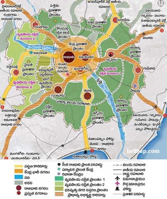
2) Total land under Amaravati: 53621 acres (217 sq.k.m.). This includes the 33000 acres land pooled by the Government from farmers, roads, endowments and forest department lands)
3) Land to be allocated for Infrastructure projects: 22000 acres
4) Land to be distributed to farmers: 10000 acres.
5) Land to be available for Government after water ponds, forest lands, housing for employees etc.: 8000 acres.
6) Land to be allocated for seed capital where Government offices will be located: 3706 acres.
Urban Growth corridors:
1) Narasaraopet – Sattenapalli – Amaravati – Capital City
2) Vijayawada – Nuzvidu – Jagadalpur NH
3) Nizampatnam Port – Tenali – Capital City
Central Mega City: Joining Vijayawada and Mangalagiri with Inner Ring Road considered as Mega City. Main Cities in the capital region are Vijayawada, Mangalagiri, Guntur, Tenali, Sattenapalli, Nandigama, Gannavaram, Nuzividu and Gudivada.