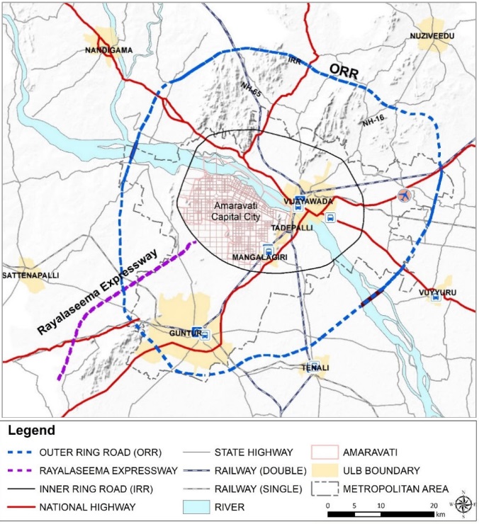
Amaravati ORR Latest Map, Alignment and Updates
Amaravati, the future capital of Andhra Pradesh, will be surrounded by a six-lane access-controlled highway that would be 189 km long and part of the NHAI & APCRDA expressway project. Connecting Vijayawada, Guntur, Tenali, and surrounding districts is this six-lane greenfield bypass.
Plans for it are included in the 2050 masterplan of the Andhra Pradesh Capital Region Development Authority (APCRDA). The Amaravati ORR has not yet released its detailed project report (DPR). In order to build it, land acquisition has not yet begun.
Along the way, 22 Mandals with 87 villages will be traversed.
The project will be 189 km long with 6 lanes.
National Highways Authority of India (NHAI) is the owner.
Two phases will be developed for the project:
Eastern Half: 78 kilometers
Half-Western: 111 kilometers
A six-lane, controlled-access split highway with 150 meters of right-of-way, three tunnels, nine interchanges, and two bridges over the Krishna River are all part of the design plans. It will connect to Machilipatnam Port, all main expressways, state highways, and federal highways.
Present Situation
Right now, the project is in the proposal stage. For its construction project, tender notices are still pending.
Road Map The Japan International Cooperation Agency (JICA) study shows the approximate / suggestive alignment of the Amaravati Outer Ring Road. There is no final alignment ready or set.