Ongole is going to change it fortunes with the announcement of Ongole Urban Development Authority (OUDA) by the Government of Andhra Pradesh. All the towns, 39 mandals and 345 villages in and around Ongole will come under OUDA. AP Government has issued orders in this regard. OUDA is going to become third largest urban development authority in the state. Following are details of OUDA map, mandals and villages included, population, and area of the new Ongole.
39 Mandals:
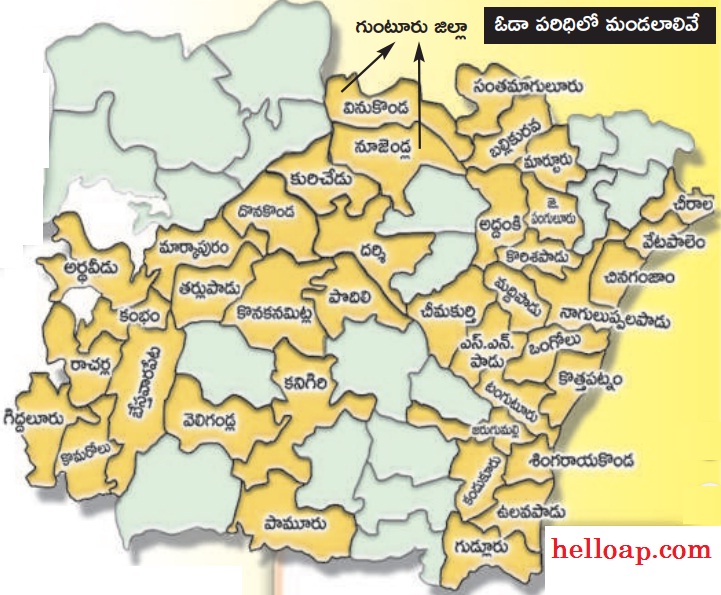
Following are the 39 mandals to be included in OUDA. Parts of some mandals in Guntur district also included in the OUDA map.
These are the mandals: Ardhaveedu, Kambham, Racharla, GIddaluru, Komarolu, Bestavaripet, Veligandla, Markapuram, Tarlupadu, Konakanamitla, Kanigiri, Pamuru, Donakonda, Podili, Kurichedu, Darsi, Vinukonda, Nuzendla, Santhamaguluru, Ballikurava, Martur, Addanki, J Panguluru, Korisapadu, Maddipadu, Chimakurthy, SS Padu, Tangutur, Jarugumalli, Kandukur, Gudlur, Vulavapadu, Singarayakonda, Kothapatnam, Ongole, Naguluppalapadu, Chinaganjam, Vetapalem and Chirala.
Towns to be included:
OUDA will include the towns such as Chirala, Kandukur, Markapuram, Giddalur, Kanigiri, Addanki and Chimakurthi (Nearby villages).
OUDA in Statistics:
Name: Ongole Urban Development Authority – OUDA
Scope: 345 villages in 39 mandals (including 15 villages of 2 namdals in Guntur district)
Extent: 4864 Square kilometers.
Population: 18,24,408
The creation of OUDA is likely to change the pace of development in the district. Several projects like housing and infrastructure will be improved in OUDA area in the near future.
How do, creation of ouda is going to influence the development of ongole region.