Reginal Ring Road (RRR) is another huge infrastructure project in and around Hyderabad. Proposed RRR is likely to further boost real estate sector in Hyderabad. Government of Telangana has decided to make RRR a big project connecting various important highways leading to Vijayawada, Srisailam, Mumbai etc.
Four Lanes: Proposed Regional Ring Road (RRR) will be a length of 338 kilometers, much larger than ORR (Outer Ring Road). This will be a four lane expressway.
Also Read: RRR Distance and Phases with Map
Areas to be covered:
RRR will connect important places around Hyderabad. These include Shankarapally, Shadnagar, Kadthal, Yacharam, Choutuppal, Bhuvanagiri, Turkapalli, Jagdevpur, Gajwel, Toopran, Narsapur, Sangareddi, and Kandi. Following is the map of RRR.
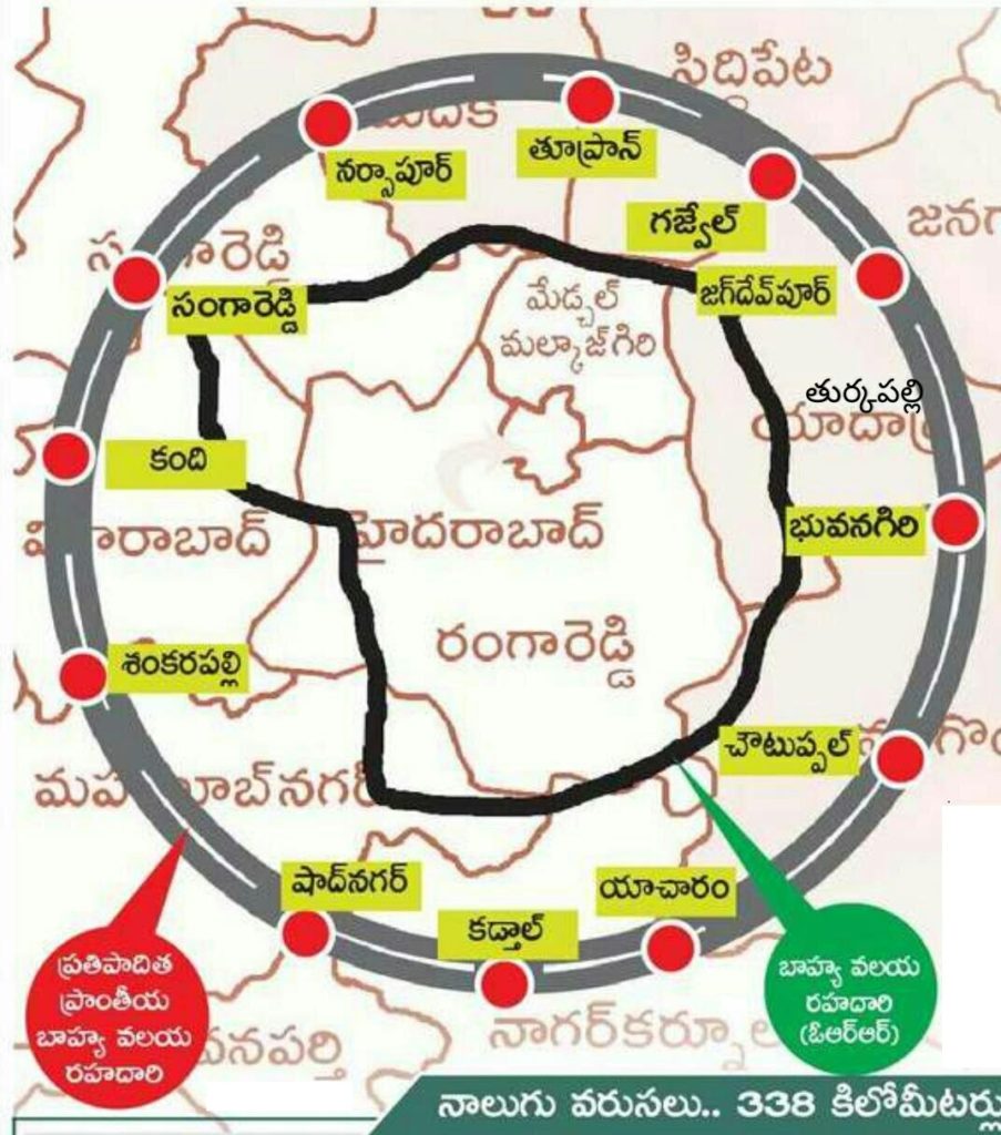
The Government is stressed on developing RRR on par with international standards. Junctions leading to Vijayawada, Bengaluru, Nagpur and Mumbai will be developed with excellent amenities. The Government is proposed to provide an additional 300-500 acres for amenities such as parking, rest rooms, food courts, children play areas etc.
125 Villages:
The Regional Ring Road will be outside the existing ORR. It will cover more than 125 villages in Nalgonda, Sangareddy, Mahaboobnagar, Rangareddy, Bhuvanagiri districts. Detailed DPR is under preparation and Government may start the work after due approvals. The Central Government has also approved the RRR project and may provide some financial assistance.
just tell us which villages does the road is going to make from shadhnagar to kadthal
Regional Ring Road Sangareddy Narsapur
Please can anybody list out those 125 villages that are covered in regional ring road.
RRR Covered villages in choutuppal mandal please
Can we know my village in that NEELAMBHAVI BHONGIr
Shadnagar
How much road extent from present bhongir -Gajwel road please let me know
How do I know if my land is being acquired by the government… How will I get the notice ?
Pls tell, Exactly rrr passed point on bangalore highway.
Please list out the villages and the survey numbers
Thank you
Can anyone reply for me from how many kilometres bhongir RRR WAILL BE THERE AND WHAT ATE THE VILLAGES WOULD BE COVERED
RRR Covered villages in Narsapur mandal please
Is our village mogilipaka in valigonda mandal covered
IRIGIPALLY SAGAREDDY MODAL COVERD AREAS