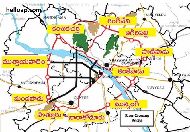
Government of Andhra Pradesh has finalised the prestigious ORR (Outer Ring Road) project in Amaravati, the new capital city of AP. The ORR will touch 87 villages and important among them are Kanchikacharla, Aagiripalli, Pottipadu, Kankipadu, Munnangi, Narakoduru, Pothuru, Mandapadu and Muthayapalem. Following are the details of 3 packages / routes, distance, map of ORR and cost of the project.
Villages in Krishna and Guntur Districts:
The ORR in Amaravari will cover 49 villages in Krishna district and 38 villages in Guntur district. Total cost of the ORR project is Rs. 17,761 crores. Here are more statistics:
Total length: 189 KM
Breadth of ORR: 150 meters
Total lanes: 6 lanes
Service roads breadth: 7 meters
Footpath: 2.5 meters
Total land required: 3404 hectars
First Phase of ORR in Amaravati (NH 65 – NH 16):
Route: Kanchikacharla – Pothuru
Length: 63 KM
Second Phase of ORR in Amaravati (NH 16 – NH 65):
Route: Pothuru – Pottipadu
Length: 53 KM
Third Phase of ORR in Amaravati (NH 16 – NH 65):
Route: Pottipadu – Kanchikacharla
Length: 65 KM
Survey number provided
Can you please show the information source for this article? I searched in crda website but could not get the source. Thanks.
Pl iwant apcrda update daily news