Eluru (West Godavari district) got a new year gift from AP Government in the form of making it an urban development authority. Eluru Urban Development Authority (EUDA) is created officially with the inclusion of 9 municipalities, 35 mandals and 463 villages with an area of 3327 sq.kms. Here are we giving all the details of EUDA such as mandals, municipalities and villages included in EUDA:
Mandals included completely in EUDA:
Denduluru, Pedapadu, Tanuku, Vundrajavaram, Penugonda, Achanta, Yalamanchili, Narasapuram, Palakollu, Atthili, Penumantra, Poduru, Iragavaram and Veeravasaram mandals along with all the villages are completely included in EUDA, West Godavari district.
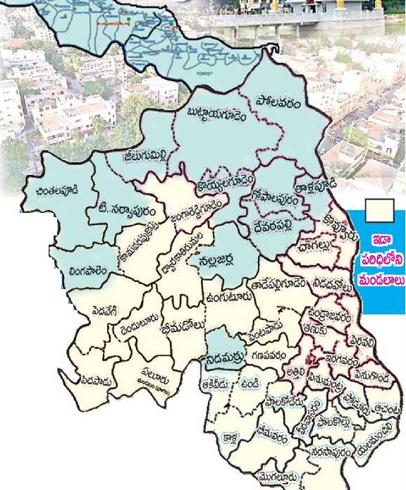
Mandals partially included in EUDA:
Some villages of Bhimadolu, Chagallu, Dwaraka Tirumala, Eluru, Kovvur, Nidadavolu, Pedavegi, Pentapadu, Peravali, Tadepalligudem, Vunguturu, Kamavarapukota, Jangareddygudem, Mogalturu, Bhimavaram, Akiveedu, Vundi, Palakoderu, Ganapavaram, Kalla, T Narsapuram are merged with the newly created EUDA.
Rural areas of EUDA will see good infrastructure development with the creation of a separate authority. Housing, roads, transport, drainage, water supply etc will be improved in the villages and urban areas of EUDA as more funds will be allocated by the Government.
very useful website.
Dear sir,
I am R V Apparao from Nidadavole, wish to know the EUDA Zoning regulations
So, please send the details to my e mail id : rvapparao@hotmail.com